The Rtk GPS Base and Rover with Function Navigation**Main Features of V30 RTK GPS:Multi-constellation tracking220 tracking channels.Supports GPS, GLONASS, GALILEO, BDS, SBAS.NGS approved GNSS antenna. Intelligent operationEquipped with a smart speaker guiding the whole operation.Multi one-button functions make fieldwork easier, such as auto base setup by one button, the rover can get fix solution once it is turned on. Diversify RTK applicationOptional transceiver UHF radioThe transceiver UHF radio enables the working mode to be switchable between base and rover.2-watt HI-TARGET internal UHF radio and 2-watt Pacific Crest TrimTalk© internal UHF radio are optional. Pacific Crest TrimTalk© internal UHF radio is compatible with other radios.Removable internal UHF radio enables users to fix or exchange simply. Seamless operation in CORS systemBuilt-in GPRS/GSM/3G module ensures that the V30 works perfectly with network RTK positioning. Long-life batteryPowered by 5000mAh Li-ion battery.Static working time 13 - 15 hours.RTK Rover (UHF/GPRS/GSM) working time 10 - 12 hours.RTK Base working time 8 - 10 hours. Rugged and unique designIP67 dust/water protection.Withstands 3-meter natural fall onto concrete.Rapid tracking and perfect avoidance or reduction of obstruction and multipath effect to ensure superior positioning capability. **Technical Parameters of V30 GNSS RTK GPS Base and Rover:Technical Parameters Measurements 220 tracking channelsAdvanced Pacific Crest Maxwell 6 Custom Survey GNSS TechnologyHigh precision multiple correlator for GNSS pseudo range measurementsUnfiltered, unsmoothed pseudo range measurements data for low noise, low multipath error, low time domain correlation and high dynamic responseVery low noise GNSS carrier phase measurements with 99.9%Realtime Kinematic(RTK) surveyingHorizontal: 8mm+1ppm RMSVertical: 15mm+1ppm RMSInitialization time: typically < 8 secondsInitialization reliability: typically > 99.9% Code Differential GNSS positioningHorizontal: 25cm+1ppm RMS Vertical: 50cm+1ppm RMS SBAS[iv]:0.50mHorizontal,0.85m Vertical** Main Application of GPS Surveying Instrument:1.Construction Layout2.Electric power transportation3.CORS application4.CORS site5.Control survey6.Data collection7.Water Measurement8.Construction Positioning (water)The Rtk GPS Base and Rover with Function Navigation/* January 22, 2024 19:08:37 */!function(){function s(e,r){var a,o={};try{e&&e.split(",").forEach(function(e,t){e&&(a=e.match(/(.*?):(.*)$/))&&1
Quality The Rtk GPS Base and Rover with Function Navigation products, provide good price The Rtk GPS Base and Rover with Function Navigation from .
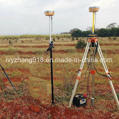
Larger photo of The Rtk GPS Base and Rover with Function Navigation
Related products about The Rtk GPS Base and Rover with Function Navigation
-
 Waste Tyre Plastic Recycling Machinery Machine Tire Crusher Production Line Rubber Crumb Grinding Machine Equipment Tire Shredder
-
 Stretch Plastic Blowing Pet Bottle Making Blow Molding Machine Bottles Stretch Automatic Pet Bottle Blowing Machine
-
 Waste Plastic Pet Bottle, Water Bottle Flake, PP/HDPE/LDPE PE Film Jumbo Woven Bags Plastic Crusher Machine, Plastic Crushing Washing Recycling Machine
-
 Type 2 Wall-Mounted Electric Car Charging Station 7kw /11 Kwelectric Vehicle Charging Station Home Wallbox AC EV Charger Single Phase or 3three Phase
-
 G-View G12W Wholesale Auto Car LED Headlight Bulb High Power H13 H11 9005 H7 H4 Car LED Headlights LED Car Lights
-
 New Design Porcelain Round Plates Dinner Set for Wedding and Banquet
-
 China 2023 New Design Super Soft 100% Polyester Microfiber Knitted Oversized Decoration Hoodie Blanket
-
 Handmade Art Creative Materials Thickened White Paper Cup DIY Disposable Handmade Colored Paper Cup


