CORE TECHNOLOGY*High Performance measurement engine*Lightweight appearance design*Radio Network data communication*Super configuration 8GB of storage*Intelligent Application*Android controller Ihand30*Professional Hi-survey measurement Software SPECIFICATIONS MEASUREMENTS440 ChannelsAdvanced Pacific Crest Maxwell 6 Custom Survey GNSS TechnologyHigh precision multiple correlator for GNSS pseudo range measurementsUnfiltered, unsmoothed pseudo range measurements data for low noise, low multipath error, low time domain correlation and high dynamic responseVery low noise GNSS carrier phase measurements with 99.9%RealtimeKinematic(RTK) surveyingHorizontal: 8mm+1ppm RMSVertical: 15mm+1ppm RMSInitialization time: typically < 8 secondsInitialization reliability: typically > 99.9%Code Differential GNSS positioningHorizontal: 25cm+1ppm RMSVertical: 50cm+1ppm RMSSBAS[iv]: 0.50m Horizontal, 0.85m VerticalHARDWAREPhysicalDimensions (W x H): 19.50cm x 10.40cm(7.68 in x 4.09 in)Weight: 1.3kg (2.86lb) with internal battery, internal radio, standard UHF antennaOperating temperature: -45ºCto +65ºCStorage temperature: -55ºC to +85ºCHumidity: 100%, consideringWater/dustproof: IP67 dustproof, protected from temporary immersion to depth of 1m (3.28ft)Shock and Vibration: Designed to survive a 3m(9.84ft) natural fall onto concreteElectricalPower 6V to 28V DC external power inputPower consumption 2.5WAutomatic Switching between internal power and external powerRechargeable, removable 7.4V, 4400mAh Lithium-Ion battery in internal battery compartmentInternal battery lifeStatic 13 - 15 hoursRTK Rover (UHF/GPRS/3G) 10 - 12 hoursRTK Base 8 - 10 hoursI/O interface1 x Bluetooth1 x standard USB2.0 port2 x RS232 serial port2 x DC power input (8-pin & 5-pin)SoftwareField SoftwareThere are optional field controllers and software in the V30 package. The controllers with OS Microsoft Windows Mobile 6.5 are fully compatible with the third party software such as Carlson SurvCE, MicroSurveyFieldGenius, Digiterra Explorer, EsriArcPad etc. besides standard field&GIS software made by HI-TARGET. HI-TARGET controller with WiFi, Bluetooth, and GPRS/3G is completely wireless to connect to any device, collect data and connect to server simultaneously and seamlessly.Post-processing SoftwareHI-TARGETGeomatics Office (HGO) software provides total GNSS solution with a complete suite of programs to support HI-TARGET GNSS receivers. Standard Rinex data and HI-TARGET raw data can be processed flexibly and easily.COMMUNICATION AND DATA STORAGEGPRS/GSM or 3GFully integrated, fully sealed internal GPRS/GSM or 3GNetwork RTK (via CORS) range20-50kmHI-TARGET internal UHF radio (standard)Frequency: 460 MHz with 116 channelsTransmitting Power: 0.1W, 1W, 2W adjustableTransmitting Speed: Up to 19.2KbpsWorking Range: 3~5Km typical, 8~10km optimalHI-TARGET External UHF radio (standard)Frequency: 460 MHz with 116 channelsTransmitting Power: 5W, 10W, 20W, 30W adjustableTransmitting Speed: Up to 19.2KbpsWorking Range: 8~10Km typical, 15~20km optimalData storage64MB internal memoryData formats(1Hz positioning output, up to 50 Hz - depends on installed option)CMR: sCMRx, CMR, CMR+input and outputRTCM: RTCM 2.1, 2.2, 2.3, 3.0, 3.1 input and outputNavigation outputs ASCII: NMEA-0183 GSV, AVR, RMC, HDT, VGK, VHD, ROT, GGK, GGA, GSA, ZDA, VTG, GST, PJT, PJK, BPQ, GLL, GRS, GBSNavigation outputs Binary: GSOF1 Pulse Per Second OutputCompany Profile Our company to provide professional surveying instruments and surveying service, and with rich experience in export trade, We have many customers abroad.Because of its high cost performance, it is deeply loved by customers all over the world, especially in African countries, Southeast Asian countries, South American countries and Oceanian countries. We have many customers in Tanzania, Uganda, Zambia, Cote d'Ivoire, Cameroon, Zimbabwe, Congo, India, Singapore, Pakistan, Mongolia Brazil, etc.Our company mainly sales of Total station, Auto/digital level, Optical /electronic theodolite, GNSS RTK, Laser distance meter, Handheld GPS, Drone, Surveying accessories, Surveying software, etc. We have good price with Trimble, Leica, Hi-target, South, Kolida, Sanding, Ruide, Chc, Stonex, Foif, Tersus, sokkia, spectra, nikon, Topcon, etc. And we keep good cooperation with surveying accessory manufacturer.The Company's employees graduated from engineering, surveying professional institutions of higher learning, with professional knowledge, is a high-quality sales and service team to provide you with excellent quality instrument service and efficient surveying solutions.Our goal: Be a best and professional export supplier of surveying instruments.Packing details FAQService1.Any inquiries will be replied within 12 hours.2.All our products have one year warranty, And we sure the products will be free from maintenance within warranty period.3.All products will have been strictly quality checked in factory before sending out. We accept payment by TT,Pay
Quality China Hot Selling Gnss Receiver Hi-Target V30/V30 Plus GPS Rtk products, provide good price China Hot Selling Gnss Receiver Hi-Target V30/V30 Plus GPS Rtk from .
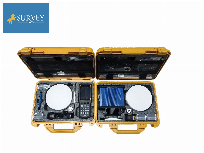
Larger photo of China Hot Selling Gnss Receiver Hi-Target V30/V30 Plus GPS Rtk
Related products about China Hot Selling Gnss Receiver Hi-Target V30/V30 Plus GPS Rtk
-
 Waste Tyre Plastic Recycling Machinery Machine Tire Crusher Production Line Rubber Crumb Grinding Machine Equipment Tire Shredder
-
 Stretch Plastic Blowing Pet Bottle Making Blow Molding Machine Bottles Stretch Automatic Pet Bottle Blowing Machine
-
 Waste Plastic Pet Bottle, Water Bottle Flake, PP/HDPE/LDPE PE Film Jumbo Woven Bags Plastic Crusher Machine, Plastic Crushing Washing Recycling Machine
-
 Type 2 Wall-Mounted Electric Car Charging Station 7kw /11 Kwelectric Vehicle Charging Station Home Wallbox AC EV Charger Single Phase or 3three Phase
-
 G-View G12W Wholesale Auto Car LED Headlight Bulb High Power H13 H11 9005 H7 H4 Car LED Headlights LED Car Lights
-
 New Design Porcelain Round Plates Dinner Set for Wedding and Banquet
-
 China 2023 New Design Super Soft 100% Polyester Microfiber Knitted Oversized Decoration Hoodie Blanket
-
 Handmade Art Creative Materials Thickened White Paper Cup DIY Disposable Handmade Colored Paper Cup


